Advisory Archive
Last night the mountains received 3-6 inches of snow. Wind has been out of the northwest at 10-15 mph with gusts of 25-40 mph. This morning temperatures are mid-teens to low 20s F. Today temperatures will reach mid-20s F and wind will be west-northwest at 10-25 mph with clearing skies. The next few days will be partly cloudy to mostly sunny with temperatures reaching low 30s F during the day and teens to low 20s F at night. On Thanksgiving, strong westerly wind is expected with gusts up to 30-40 mph. There is a slight chance for maybe an inch of snow on Friday night.


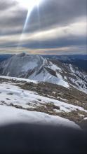
By Saturday morning 10” of snow fell in Hyalite with 4-7” everywhere else. It’s been clear since then, but windy at the ridgetops, especially around Bozeman. Yesterday, gusts approached 50 mph from the west and blew 10-20 mph over the weekend. Temperatures were mostly below freezing during the day and teens at night.
This week will be mostly dry other than a chance of 1-2” of snow falling Tuesday night. Winds will remain gusty out of the west through the early week. Mountain temperature will reach into the 40s today and cool the rest of the week with highs near freezing and lows in the teens.

Since Monday morning, a trace to 2 inches of snow has fallen across the advisory area. Temperatures cooled dramatically on Monday, getting down into the single digits F and staying below or near freezing for the rest of the week. Strong winds have been out of the west and southwest.
Snow will begin today and continue overnight. Expect 3-5 inches of new snow around Bozeman and Big Sky, 2-4 inches around West Yellowstone and 1-3 inches near Cooke City before snowfall tapers off tomorrow morning. Temperatures over the weekend will range from the low 20s to high 30s F. Skies will clear tomorrow and stay clear on Sunday. Winds will be moderate out of the southwest and west.

Since Friday morning the mountains around Cooke City received 7” of dense snow with 2” in the Southern Madison Range. Temperatures were near freezing to the mid-40s F for the weekend with 15-25 mph winds and strong gusts from the west to southwest.
Mountain temperatures will range from the upper 30s to 50 degrees F on Monday before cooling and remaining below freezing for the remainder of the week. Snow returns with 1-3” Tuesday into Wednesday and another round of precipitation arriving as we head into the weekend. Winds from the southwest to the west will be 25-35 mph with gusts of 50-60 mph until midweek.

Since last Sunday the mountains received 8-12” of snow. Wind has been 10-20 mph with gusts of 35-40 mph, generally out of the west with shifts to northwest and southwest. Temperatures are high 20s to low 30s F this morning. Today, temperatures will reach mid-30s to low 40s F under mostly cloudy skies with a chance for light precipitation.
Weather this weekend will be windy and warm, with a little water. Westerly wind will increase to 30-40 mph with gusts near 60 mph, and temperatures will reach mid-30s to low 40s F during the day and drop to high 20s F at night. Occasional showers on Saturday and Sunday could produce 1-3” inches of snow in the mountains with 4-7” near Cooke City. Colder temperatures will return Tuesday with chances for snow mid-week and next weekend.

Last night’s storm dropped 6-9” of heavy snow in the Bridger Range, near West Yellowstone, and Cooke City with 1-2” near Big Sky and in Hyalite. Overnight wind was out of the southwest at 15-25 mph with gusts of 40-60 mph. Today wind will be west-southwest at 15-25 mph and temperatures will reach low 30s F. A couple more inches of snow may fall by the end of today. Monday will host mostly clear skies with temperatures in the low 30s F. The next round of snow is slated for Tuesday night and Wednesday.
Find current weather data on our weather stations in Cooke City and Lionhead, as well as Bridger Bowl’s weather stations, and SNOTEL sites throughout our advisory area.

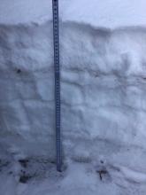
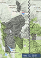
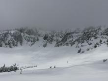
Since Sunday evening, 6 inches to a little over 1 ft of snow has accumulated across Southwest Montana (photo and weather log). Snowfall will taper off today as the storm system moves to our east. There may be a few more snow showers on Wednesday and Thursday before warmer and dryer conditions return for the following week.
For current weather data check SNOTEL sites throughout our advisory area and our weather log which will be updated throughout the fall. The GNFAC will be installing our weather stations as conditions allow in the coming weeks.

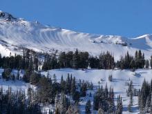
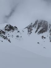
Spring weather can be highly variable and create a mix of avalanche problems to watch for. Snow conditions and snow st stability an change drastically from day to day or hour to hour. Anticipate rapid change and plan accordingly. Plenty of snowfall over the winter with more spring snow to come makes avalanches possible into summer.


This morning temperatures are 40s-50s F, wind is west-southwest at 15 mph with gusts of 20-30 mph and skies are partly cloudy. Today will be mostly sunny with temperatures reaching mid-60s F with west wind at 15-30 mph. Tomorrow will be ten degrees cooler with sunny skies turning to rain late afternoon.
On Sunday morning there is a chance for snow with temperatures dropping to low 30s to 40s F, and wind shifting to the north at 15-20 mph. Next week will start cloudy with light snow or rain, and temperatures in the high 20s to low 40s F. Minimal snow accumulation is expected until next weekend. The most will be on Sunday morning with possibly 1-2” south of Bozeman and 2-5” near Cooke City.


Since Saturday evening the mountains got 14-16” of snow near Cooke City and the southern Madison Range, 10-12” in the Bridger Range, 9” near Big Sky and 4-5” in Hyalite and West Yellowstone. Wind has been west-southwest at 10-20 mph with gusts of 20-35 mph. This morning temperatures are mid-20s to low 30s F. A few more hours of precipitation today will deliver 1” of snow near Bozeman and Big Sky with 2-4” near Cooke City by tonight.
Tomorrow and Wednesday, temperatures will reach low 40s F under clear skies with wind shifting to the north at 5-10 mph. On Thursday and Friday, temperatures will reach highs in the 50s with overnight lows in the 30s and 40s F. Next weekend will remain warm and sunny before another round of colder temperatures and possible snow to start next week.