Good morning. This is Doug Chabot with the Gallatin National Forest Avalanche Advisory issued on Wednesday, March 4th, at 7:30 a.m. Moonlight Basin Ski Patrol, in cooperation with the Friends of the Avalanche Center, sponsor today’s advisory. This advisory does not apply to operating ski areas.
The weather station reports took a bit of deciphering this morning to separate out the rain and snowfall. Since early yesterday morning five inches of snow fell in the Bridger Range while one inch dropped around Big Sky and other northern areas. Six inches are in the mountains outside West Yellowstone and ten new inches are in Cooke City. Wind speeds have calmed to 10-20 mph from the southwest with temperatures in the low to mid 20s. Winds will pick up this afternoon as a few more disturbances roll through and drop snow. I expect one to three inches in the north and almost eight inches in the southern mountains by morning.
The Lionhead area near West Yellowstone, the mountains around Cooke City and the Washburn Range:
The mountains outside West Yellowstone and Cooke City have seen 6-10 inches of snow, but that’s not the whole story. As forecasters we’re interested in how much weight was added to the snowpack. The snow that fell was very, very dense, and in some cases it rained before the snow fell. The remote SNOTEL sites outside West Yellowstone show 1.0 inch of water fell since 3 a.m. yesterday, while 1.3 inches fell near Cooke City. This is rapid loading and it’s still snowing.
Karl and I snowmobiled far and wide over Lionhead yesterday and found only one natural avalanche. If this was your only piece of information, you might deduce the snowpack is generally safe. But you’d be wrong. Our stability tests fractured very clean, fast and crisp—a real eye opener. Fractures were occurring on small facets one to two feet under the surface as well as a foot and a half off the ground. This layer near the ground seems to have gotten more reactive lately, which I’m not happy about.
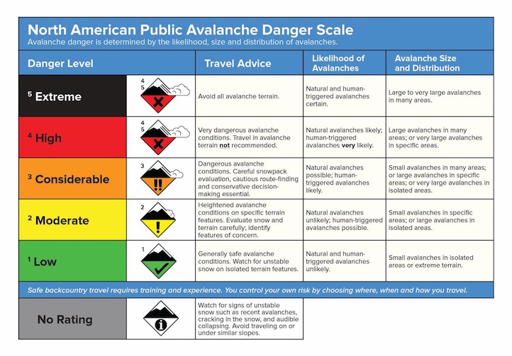
I was in Cooke City on Sunday and determined that buried facets about 2 feet deep are still unstable on some slopes. Two small avalanches over the weekend prove this. Since Monday night, Cooke has gotten more snow water equivalency than West Yellowstone. It’s still snowing and there are scattered weak layers straining to support this dense snow. More loading today will only increase the likelihood of triggering an avalanche. Unfortunately, you may not see natural activity as a warning sign. For today, I’m rating the avalanche danger CONSIDERABLE on all slopes.
The Bridger, Gallatin and Madison Ranges,
The Bridger Range got 4 inches of snow yesterday morning and another inch last night. Bridger Ski Patrol reported the new snow sluffed easily in the morning, but then glued down. That’s the beauty of wet, dense snow—it sticks like oatmeal to the slopes and doesn’t move. The northern Gallatin and Madison Ranges, including the Lone Peak area, only got an inch of snow while further south three inches accumulated in Carrot Basin. Although the backcountry has remained quiet in the last few days, there are still scattered pockets of unstable snow you could trigger. Mark, as well as another party, got collapsing and cracking in the Bridgers this weekend. Further south in Taylor Fork we’re still getting clean fractures on facets near the ground. We also know that pockets of surface hoar are buried 1-2 feet deep in the southern mountains which could avalanche too. Consequently, for today, the avalanche danger is rated MODERATE.
UPCOMING EVENTS
Make plans to attend the 28th Annual Pinhead Classic Telemark Festival on March 14th at Bridger Bowl. This year’s theme is “The Olympics” with events for all ages and all abilities. Prizes are awarded for everything but the fastest time and all proceeds benefit the Friends of the Avalanche Center. A registration fee of $30 gets you a ½ -day rate lift ticket, t-shirt, commemorative pint glass, multiple laps on the dual slalom course, numerous prizes and awards, and dinner, dancing, and live music at the Emerson that evening. Visit www.pinheadclassic.com for more information.
I will issue the next advisory tomorrow morning at 7:30 a.m. If you get out in the backcountry give us a call or send us an email with your observations. You can reach us at 587-6984 or at mtavalanche@gmail.com.