Good morning. This is Mark Staples with the Gallatin National Forest Avalanche Advisory issued on Monday, March 9th, at 7:30 a.m. Bridger Bowl in cooperation with the Friends of the Avalanche Center, sponsor today’s advisory. This advisory does not apply to operating ski areas.
Today is a good one to call in sick with powder fever. Yesterday’s storm dropped 16 inches of cold smoke in the Bridger Range, 12 inches near West Yellowstone, 8 inches near Cooke City, and 4-6 inches near Big Sky. At Bridger Bowl very little wind accompanied this snow while other areas experienced strong winds before they calmed late last night. This morning light winds were blowing 5-10 mph from the southwest except in the Bridgers where they shifted to the east. Temperatures range from a few degrees below zero F to the north to a few degrees above zero F to the south.
Today winds will remain light and temperatures will climb to near 10 degrees F. Mostly cloudy skies will bring light snow mostly near West Yellowstone and Cooke City where 4-6 inches will accumulate by Tuesday morning while the rest of the area will get 1-2 inches. Don’t despair because more snow should fall during the day on Tuesday.
The Bridger, Gallatin and Madison Ranges, the Lionhead area near West Yellowstone:
The simple part of today’s advisory is that significant snowfall combined with significant weak layers means avalanches are very likely today. Since snowfall began in the middle of last week, numerous natural and human triggered avalanches have occurred and more will occur today. Much of this activity has occurred in the Bridger Range. When the sun appeared on Saturday, many natural avalanches were observed and photos can be seen at: http://www.mtavalanche.com/photos/photos.php
On Saturday a skier was caught and possibly buried but uninjured in an avalanche on the west side of the Bridger Range. We do not have any more details on this incident, but I would not feel comfortable traveling on that side of the range to investigate this avalanche. Yesterday in the northern Bridgers skiers cut the convex rollover on a south facing slope and triggered an avalanche about 3 ft deep. On Mt Ellis Doug and I skinned to the summit and followed old ski tracks down to the start of avalanche terrain. These skiers apparently dug a snow pit, did not like what they saw, and traversed to safe terrain. We did the same. Another group in the northern Gallatin Range found a sensitive snowpack and poor results in their stability tests.
What we found on Mt Ellis is very similar to what we’ve found through much of the advisory area. Warm sunny days and clear cold nights from mid January to mid February created a very weak layer of snow near the top of the snowpack. Since February 15th this layer has been buried by a series of storms and has reached its breaking point. On south facing slopes this layer exists near an ice crust now buried 2-3 ft deep. On north facing slopes this layer is now buried 3-5 ft deep. See a photo of this layer breaking cleanly in my stability tests in the southern Madison Range at: http://www.mtavalanche.com/photos/photo_popup.php?photo=1236302669
Unfortunately this weak layer did not develop uniformly and its formation was not aspect dependent. The biggest factor was snow depth during the dry period. It is worse on slopes that had a more shallow snow pack and better on slopes that had a deeper snowpack; however, the only way to truly assess this weak layer is by digging a snow pit and performing multiple stability tests. Similar conditions with considerable variability exist near Sun Valley in Idaho where a skier was killed in an avalanche on Friday. For a report of this accident visit: http://www.avalanche.org/data.php?date=&sort=&id=459
Today natural and human triggered avalanches will occur on any wind loaded slope. Unfortunately this includes slopes loaded by wind drifted snow several days ago. These slopes may be hard to identify in the Bridger Range but it doesn’t matter because avalanche terrain should be avoided. For today any slope affected by the wind has a HIGH avalanche danger and all other slopes have a CONSIDERABLE danger.
The mountains around Cooke City and the Washburn Range:
The mountains near Cooke City have consistently received more snow this winter, thus they did not form as bad of a weak layer during the dry period from mid January to mid February. The snowpack in this area is generally capable of supporting the new snow although Doug found isolated areas that will not. The primary concerns today are avalanches within the storm snow especially on wind loaded slopes where the avalanche danger is CONSIDERABLE. All other slopes have a MODERATE danger where avalanches remain definitely possible.
UPCOMING EVENTS
Make plans to attend the 28th Annual Pinhead Classic Telemark Festival on March 14th at Bridger Bowl. This year’s theme is “The Olympics” with events for all ages and all abilities. Prizes are awarded for everything but the fastest time and all proceeds benefit the Friends of the Avalanche Center. A registration fee of $30 gets you a ½ -day rate lift ticket, t-shirt, commemorative pint glass, multiple laps on the dual slalom course, numerous prizes and awards, and dinner, dancing, unlimited beverages, and live music at the Emerson that evening. Visit www.pinheadclassic.com for more information.
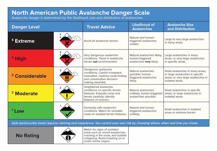
NEW DANGER SCALE
The avalanche danger scale is being revised for next winter. We value your thoughts, so please help with this project by completing a survey found on the following link:
http://surveys.globalepanel.com/wix/p319164581.aspx
Doug will issue the next advisory tomorrow morning at 7:30 a.m. If you get out in the backcountry give us a call or send us an email with your observations. You can reach us at 587-6984 or at mtavalanche@gmail.com.