Good Morning. This is Mark Staples with the Gallatin National Forest Avalanche Advisory issued on Saturday, December 5 at 7:30 a.m. Gallatin County Search and Rescue, in cooperation with the Friends of the Avalanche Center, sponsor today's advisory. This advisory does not apply to operating ski areas.
Snowfall started early this morning as a deep, upper level trough descended over southwest Montana bringing a large arctic airmass behind it. At 7am temperatures were near or just above 0 degrees F, and winds were blowing 5-10 mph from the northwest with gusts up to 20 mph. In the Bridger Range over 9 inches of the famous cold smoke has fallen near the ridge while only half that amount has fallen at lower elevations. In the Hyalite and Big Sky areas 1-2 inches has fallen, and none has fallen further south. Today cloudy skies will continue to produce snow mainly in the mountains near Bozeman where 4-6 additional inches will accumulate by tomorrow morning. 2-4 inches will fall near Big Sky and Cooke City and the mountains near West Yellowstone should only get about 1 inch of snow. Today, temperatures will drop into the negative single digits F and ridgetop winds will blow 15-20 mph from the North.
The Bridger, northern Gallatin, and northern Madison Ranges:
In the Bridger and northern Gallatin Ranges, deeper layers in the snowpack are generally strong. Our avalanche concerns exist closer to the snow surface for two reasons. Recent cold weather has produced some weak faceted snow at the snow surface which is now covered by new snow and wind slabs. Yesterday numerous skiers in the Bridger Range found sensitive wind slabs 6-10 inches deep. Most of these were small and did not contain enough snow to bury a person, but today they will be larger and a significant concern.
Eric and I investigated the snowpack in the northern Madison Range yesterday with the Yellowstone Club Ski Patrol. We found evidence of some faceting at the snow surface as well as a layer of faceted snow buried 1-1.5 ft deep on a north east aspect. Similar conditions exist in Beehive Basin. Neither of these layers will cause a significant stability concern until more snow falls and the primary avalanche concern is any recently formed wind slab which should be relatively small.
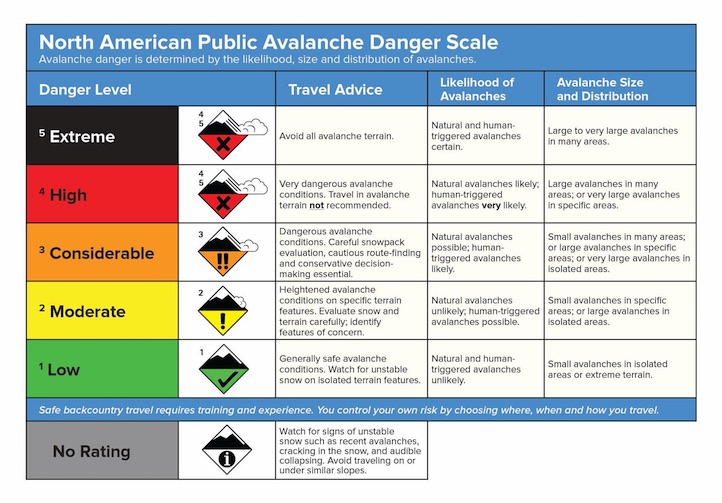
Today, a CONSIDERABLE avalanche danger exists on recently wind loaded slopes where wind slabs will easily fracture under the weight of a skier or rider. All other slopes have a MODERATE avalanche danger.
The southern Gallatin and southern Madison Ranges, the Lionhead Area near West Yellowstone, the mountains around Cooke City and the Washburn Range:
The southern areas have a mostly thinner and weaker snowpack. On Tuesday, Doug and I put up our weather station near Cooke City where we had time to briefly examine the snowpack on a north and south aspects. On the north facing slope the snow was deep and relatively strong. On the south facing slope the snow was less deep and contained numerous layers of faceted snow. In the mountains closer to West Yellowstone and the Taylor Fork drainage, we have very limited data but suspect the snowpack is very weak and faceted. If the riding is difficult or your skis sink nearly to the ground, you've found an area of very weak, faceted snow. These areas will become more of a concern once more snow falls.
AVALANCHE EDUCATION
1. On Wednesday, December 9 at 6pm a FREE one hour Avalanche Awareness Workshop will be offered at Redline Sports in Butte. Call Redline for more information at 406-782-9129
2. On Saturday, December 12 at 10am until 3pm a FREE Avalanche Awareness Workshop will be offered at the Fish and Game Office in Great Falls. This class will have multiple presentations covering terrain, avalanches, weather, rescue, and human factors.
Eric will issue the next advisory tomorrow morning at 7:30 a.m. If you get out in the backcountry give us a call or email with your observations. You can reach us at 587-6984 or email us at mtavalanche@gmail.com.