Good Morning. This is Mark Staples with the Gallatin National Forest Avalanche Advisory issued on Saturday, December 19 at 7:30 a.m. Yellowstone Rental, in cooperation with the Friends of the Avalanche Center, sponsor today's advisory. This advisory does not apply to operating ski areas.
In the past 24 hours no new snow accumulated in the advisory area. At 4 a.m. temperatures were in the high teens and low 20's with calm winds blowing 5-10 mph from the west. Expect to see some sunshine today as temperatures warm to near 30 degrees F. Winds will remain mostly calm until this afternoon when they will increase to 15-20 mph bringing clouds and some moisture. By tomorrow morning a trace to one inch of snow will accumulate, and Sunday will bring a better chance for more snowfall.
The southern Gallatin Range, the entire Madison Range, the Lionhead Area near West Yellowstone, the mountains outside Cooke City and the Washburn Range:
Yesterday while teaching a snowmobile avalanche class on Lionhead, I finally got the chance to go riding without wearing ski boots. We had lots of fun despite difficult riding from very weak, faceted snow found in the bottom half of the snowpack. This layering was immediately obvious as we starting digging our snowpits, and we easily dug to the ground in this shallow snowpack. Our stability tests produced very low scores and propagated fractures. We also observed cracking of the snowpack, a clear sign that the snowpack is unstable. Clear signs of instability have also been observed near Cooke City as well some folks riding onto steep, wind loaded slopes with reckless abandon. Hitting these slopes without a thorough stability assessment is like playing Russian roulette: it's not a question of if, but a question of when.
The mountains around Big Sky did not receive as much snow this week as did areas further south but this lack of snowfall has not mattered. The Big Sky Ski Patrol has continually used ski cuts and explosives to test slopes that do not slide one day but slide on another sometimes with the additional weight of only an inch of new snow. In another case, a snowmobiler on Buck Ridge triggered an avalanche on a small hill from 30 ft away. These are all clear signs of an unstable snowpack.
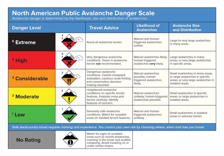
Today, loading from new snowfall and strong winds has briefly ended, and natural avalanche activity has lessened. Unfortunately the snowpack remains close enough to its breaking point that the additional weight of a skier or rider will easily trigger an avalanche. Human triggered avalanches are probable and the avalanche danger is rated CONSIDERABLE.
The Bridger and northern Gallatin Ranges:
The Bridger and northern Gallatin Ranges have weak, faceted snow within a foot of the snow surface. On many slopes this faceted snow is capped by a hard wind slab. I found this layering on Mt Blackmore when I triggered an avalanche on Wednesday. Doug and Karl found a similar situation on Saddle Peak on Thursday, and their stability tests produced clean, fast propagating fractures. See a video clip from Saddle at: http://www.youtube.com/watch?v=538ihUeQaxU
Watch for previously wind loaded slopes where underlying facets are stressed and ready to fracture. Today all wind loaded terrain has a CONSIDERABLE avalanche danger. All other slopes have a MODERATE danger.
Eric will issue the next advisory tomorrow morning at 7:30 a.m. If you get out in the backcountry give us a call or email with your observations. You can reach us at 587-6984 or email us at mtavalanche@gmail.com.