Good Morning. This is Eric Knoff with the Gallatin National Forest Avalanche Advisory issued on Monday, December 7 at 7:30 a.m. On Site Management, in cooperation with the Friends of the Avalanche Center, sponsor today's advisory. This advisory does not apply to operating ski areas.
Southwest Montana is in the firm grip of an arctic air mass. Subzero ambient air temperatures are dominating the weather pattern. These frigid temperatures are accompanied by 15-25 mph winds out of the N-NE with light precipitation. Bridger Bowl received one inch of snow yesterday afternoon. This combination of wind and extremely cold air has created dangerous wind chill factors throughout our region, sending the real feel temperature to as low as 35-45 F below zero. Today, highs will struggle to creep above 0 F with lows plummeting to -25 F tonight. Winds of 10-15 mph will be felt at lower elevations today with ridgetop winds reaching 25-35 mph. Winds will begin to decrease early Tuesday with temperatures starting to warm on Wednesday.
The Bridger, northern Gallatin, northern Madison Ranges and Mountains around Cooke City:
The Bridger Range and northern Gallatins have the deepest snowpack in the area with a settled base depth of close to three feet. This pack remains relatively strong despite the new snow, cold temperatures and strong winds we've experienced during the past few days. Strong E-NE winds have scoured north and east facing slopes while depositing firm wind slab on south and west facing slopes.
The northern Madison Range holds a slightly thinner and weaker snowpack than up north. South and west facing aspects continue to hold the weakest snow with multiple facet-crust sandwiches existing within the pack. The strong E-NE winds have loaded these weak south facing slopes making them our greatest concern. A natural avalanche was observed in Beehive Basin yesterday morning on a S-SW facing slope. This wind loaded slope broke 4-6 inches deep, 100 ft across and ran 300 vertical. Big Sky Ski Patrol also reported triggering sensitive wind slab up to a foot deep on south facing slopes. Our concerns for the mountains around Cooke City are similar to the northern Madison Range.
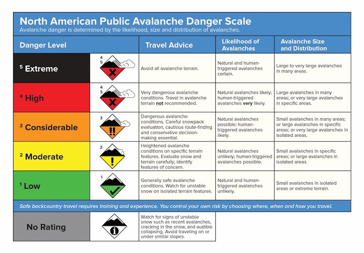
Given the recent avalanche activity and continued strong winds a CONSIDERABLE danger exists on steep wind loaded slopes. Slopes not affected by the wind will have a MODERATE avalanche danger.
The southern Gallatin and southern Madison Ranges, the Lionhead Area near West Yellowstone:
I hate to say it, but the snowpack in the southern Gallatin and southern Madison Ranges along with the Lionhead area outside of West Yellowstone has the structural stability of a house of cards. In fact, the facets are so large they actually look like individual cards sitting on top of each other. Yesterday, Doug and I traveled to the Lionhead area outside of West Yellowstone. We found two feet of completely unsupportable faceted snow. It literally felt like were traveling around in a large bowl of sugar. When we took our skis off we sunk straight to our knees in weak, rotten snow. With the facets continuing to grow, you can be sure that when the snow does arrive so will the avalanches.
I'm giving this area a LOW avalanche danger due to the lack of load.
Doug will issue the next advisory tomorrow morning at 7:30 a.m. If you get out in the backcountry give us a call or email with your observations. You can reach us at 587-6984 or email us at mtavalanche@gmail.com.
AFTERNOON TWITTER UPDATES
When we find interesting snowpack conditions or hear of avalanche activity we send out tweets. This gets you information quicker than waiting for the next morning's advisory. Check out our latest at: http://twitter.com/avalancheguys
AVALANCHE EDUCATION
1. BUTTE: On Wednesday, December 9 at 6pm a FREE one hour Avalanche Awareness Workshop will be offered at Redline Sports. Call Redline for more information at 406-782-9129
2. GREAT FALLS: On Saturday, December 12 at 10am until 3pm a FREE Avalanche Awareness Workshop will be offered at the Fish and Game Office in Great Falls. This class will have multiple presentations covering terrain, avalanches, weather, rescue, and human factors.
3. BOZEMAN: On Tuesday, December 15 at 7pm there will be a FREE one hour Avalanche Awareness Lecture at the Bozeman Public Library.
4. WEST YELLOWSTONE: TWO DAY GUIDES COURSE. On Thursday, Dec 17 (noon-5pm) at the Holiday Inn is an afternoon of avalanche lectures. Friday, Dec 18 will be outside in the field. Registration is NOT required. More info at: http://www.mtavalanche.com/education/classes/snowmobilers