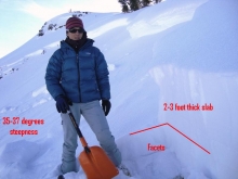
Advisory Archive
Early this morning it was snowing and 1-2 inches had accumulated in the mountains by 7 a.m. Unfortunately this fleeting storm will only lay down another ½ to 1 inch of additional snow. Temperatures were in the low 20's F and will rise into the upper 20's today under mostly cloudy skies. Light winds were blowing from the W and SW at 5-10 mph while stronger ridgetop winds in the Bridger Range were blowing about 20 mph. Today winds will continue at these speeds blowing from the W and slightly NW.
Last night 2-3 inches of snow fell in the southern Madison Range with an inch falling near Cooke City and the Yellowstone Club. Yesterday's strong southwest winds gusted into the 40s, but have lessened to 20-30 mph and will calm even further today. Mountain temperatures warmed to a few degrees above freezing, but cooled overnight into the high 20s. Under mostly cloudy skies temperatures will still hover near freezing. A weak southwest flow will create a few isolated showers bringing an inch of snow to the southern mountains.
Yesterday was another day of sunny skies and above normal temperatures. Mountains warmed into the 30s with 10-20 mph southwest winds. Last night things only cooled to just below freezing in the northern ranges and 20's in the south. Sunny skies will prevail this morning, but clouds will increase this afternoon. Temperatures will mirror yesterday and winds will be out of the southwest at 15-25 mph. The mountains around Cooke City and West Yellowstone could see a trace to one inch of snow overnight.
If you enjoyed yesterdays beautiful weather than you will definitely like the weather today. High pressure has created carbon copy weather over the past couple days and will continue to do so through tomorrow. Warm and dry conditions will prevail today, sending high temperatures close to 40 F degrees with lows falling into the teens. Winds will remain light in the valleys but will pick up this afternoon out of the west at 15-20 mph along the ridgelines. The dominating high pressure will begin to break down starting Wednesday morning, bringing with it a slight change in conditions.

Over the past 24 hours a weak shortwave disturbance has moved across Montana, depositing a trace of snow in the Gallatin and Madison Ranges along with the Bridgers while leaving the mountains around Cooke City dry. Yesterday, a west flow aloft brought stronger ridgetop winds throughout the day at 15-25 mph, but winds calmed later in the evening. Today a ridge of high pressure will continue to build over the area, bringing sunny skies and warmer temperatures. Highs today will reach almost 40 F degrees with lows dropping down around 15 F degrees. Winds will be calm in the valleys and light along the ridgetops at 5-10 mph out of the W-NW. High pressure will continue dominate the weather pattern for the early part of this week.


The high pressure that has been parked over southwest Montana for the past few days will begin to break down today as a weak weather disturbance moves in from the west. Today the temperature inversions will ease, allowing both valley and mountain temperatures to climb into the mid to high twenties with lows staying well above zero. Winds will increase from the west this morning reaching 15-20 mph along the ridgetops. Light precipitation could arrive with the front, with the potential of only a trace of new snow. Winds and precipitation will begin to taper off by late this afternoon, with cloudy skies and mild temperatures lingering through Sunday morning. Another ridge of high pressure will begin to build over the region on Sunday afternoon, providing sunny skies and warmer weather for early next week.
Today will be another beautiful day in the mountains with sunny skies and warmer temperatures than yesterday. This morning mountain temperatures were in the high teens F with valley temperatures near or below zero. This inversion was especially noticeable in West Yellowstone where valley temperatures were -32 degrees F while it was 16 degrees F near Lionhead ridge. Winds this morning were blowing 10-15 mph from the W. Under clear skies today temperatures will climb into the upper 20's F and winds will remain light at 10-15 mph. Some stronger winds are possible at lower elevations this morning as cold air mixes with warmer air.

No new snow fell during the past 24 hours. With an inversion occurring this morning, mountain temperatures were near or a few degrees below 0 F, while valley temperatures are in the negative teens F. Winds are relatively calm blowing 10-18 mph from the WNW although isolated areas have stronger winds gusting up to 30 mph as cold air drains to the valleys. These drainage winds should diminish later this morning as temperatures begin climbing to highs in the teens F at 9000 ft. Under mostly sunny skies winds will blow 10-15 mph from the WNW.


New snow is blanketing all of southwest Montana. Since yesterday morning's forecast 7-12 inches of dense snow fell. This brings the storm totals to 17 inches in the Bridgers, 10-13 inches in the northern Gallatin Range, mountains around Big Sky and Taylor Fork area. The mountains around West Yellowstone got 5-8 inches with Cooke City gaining another 15 inches. Temperatures plummeted from the mid 20s to zero last night around Bozeman. The cold air did not push too far south and Lionhead is showing a balmy 15F. West winds spiked last night with gusts near 50 mph. Currently they're blowing westerly at 10-20 mph, but 25-35 mph outside Cooke City. Other than a few isolated showers this morning, winds will remain moderate before calming tonight and temperatures will only reach the single digits up north and high teens in the south.
