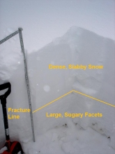
Advisory Archive
A moist northerly flow has produced a nice white Christmas and kept light snow falling over the southwest Montana through yesterday afternoon. In the past 24 hours Santa delivered 1-2 inches of new snow to the Bridgers and northern Madison Range while the Gallatin Range, southern Madison Range and mountains around Cooke City picked up a trace to 1 inch. Winds have been moderate out of the W-NW at 15-25 mph. This northerly flow is the tail end of a massive low pressure system that has been hammering the mid-west.
As this low pressure system is pushed to the east, a ridge of high pressure will build over the entire state of Montana bringing clear skies and calm winds through the weekend. For today, average seasonal temperatures will be the norm with daytime highs hitting 25-30 F degrees and nighttime lows dropping close to zero. Winds will be light out of the E-NE at 5-10 mph. This strong ridge of high pressure will dominate our weather pattern for the next three to five days making for some great weather to get out and play with the new toys.
Ho Ho Ho! Perhaps some powder hounds haven't been too naughty and just nice enough to get a trace of snow near Big Sky and one inch of snow near Cooke City. Cloudy skies this morning kept temperatures from getting too cold and were near 10 degrees F at 4 a.m. Winds have remained strong blowing from the NW at 15-30 mph. Today winds will continue from the NW and decrease slightly to 10-20 mph with temperatures climbing into the mid teens F. Mostly cloudy skies will produce some snow flurries with only a trace to 1 inch of additional snow accumulating by tomorrow morning.
Overnight temperatures dropped to near zero degrees F, and winds increased to 15-30 mph from the W and NW. In the Bridger Range at 4 a.m. winds were blowing at all elevations with gusts reaching 47 mph in the base area of Bridger Bowl. In the past 24hrs 4-5 inches of low density snow fell in the mountains near Big Sky and Bozeman. Other areas received 2-4 inches. Today, temperatures will only climb to 10 degrees F, and winds will continue blowing 15-30 mph from the W and NW.
At 6 a.m. the southern mountains have an inch of new snow with closer to three in the north. Ridgetop winds are currently blowing 15-20 mph out of the west to northwest and will continue today. An arctic airmass will further intrude into our region and drive temperatures to below zero tonight and drop another 1-2 inches of snow this morning. The northwest flow should deliver even high higher amounts in the Bridger Range, but maybe it's just wishful thinking on my part. This moist system will depart later today leaving us with sunny skies and warming, seasonal temperatures through the weekend.

In the last few days temperatures warmed and the winds died down, but don't get used to it; an arctic front sweeps in late tonight. Winds will shift from the southwest to northwest, temperatures will dip to the teens and snow will start to fall. By tomorrow morning I'm only expecting 1-2 inches, but Wednesday will be a snowy day. In fact, if the weather models are accurate the Bridgers could get their famous northwest flow which buries the slopes in choking powder. Stay tuned.
In the past 24 hours three inches of new snow has fallen in the Bridgers with two inches falling in the northern Madison Range and the mountains around Cooke City. Only a trace of new snow fell in the northern Gallatin Range and mountains around West Yellowstone. Ridgeline winds have been out of the W-SW at 25-35 mph. Temperatures are in the high 20's to low 30's.
Today we can expect more warm weather with valley temperatures climbing into the 40's with upper elevations getting well above freezing. A chance of valley rain and mountain snow will continue through the day. Winds will remain constant along the ridgtops at 15-25 mph out of the W-SW. Another storm is scheduled to move into southwest Montana tomorrow bringing a better chance of measureable precipitation.
In the past 24 hours a trace to one inch of new snow has fallen in the northern Gallatin and Madison Ranges along with the Bridgerss while no new snow has fallen in the southern ranges. This morning temperatures are on the warm side with lows in the upper 20's and ridgeline winds are blowing out of the west at 15-25 mph.
Today, an existing ridge of high pressure will break down giving way to a more unsettled weather pattern. Pacific moisture will move in from the west and combine with cold air from the north producing widespread snow showers starting this afternoon and continuing through Monday. The Bridgers and northern Gallatin Range can expect to see 4-6 inches by Monday afternoon while the northern Madison Range and mountains around West Yellowstone and Cooke City will pick up 2-4 inches. Winds will become strong out of the W-NW at 20-30 mph with the arrival of this storm.
In the past 24 hours no new snow accumulated in the advisory area. At 4 a.m. temperatures were in the high teens and low 20's with calm winds blowing 5-10 mph from the west. Expect to see some sunshine today as temperatures warm to near 30 degrees F. Winds will remain mostly calm until this afternoon when they will increase to 15-20 mph bringing clouds and some moisture. By tomorrow morning a trace to one inch of snow will accumulate, and Sunday will bring a better chance for more snowfall.

Yesterday, Lone Peak picked up 3 inches of new snow while the rest of our mountains got 1-2 inches. Overnight west to southwest winds decreased to 15-20 mph and temperatures are currently in the teens. Today will be mostly sunny with mountain temperatures reaching into the 20s again. Winds will remain light out of the west and no snowfall is expected.

In the past 24 hours the mountains around West Yellowstone have picked up 2 inches of new snow while the northern Madison range and mountains around Cooke City received and an inch. A moist westerly flow will bring strong winds and continued snow showers to our region throughout the day. This moisture will give the southern mountains an additional 1-3 inches while the northern Madison and Gallatin ranges along with the Bridgers will pick up 1-2 inches. Strong westerly winds will reach 20-30 mph on the ridgetops while the lower elevations will see calmer winds at 10-15 mph. Temperatures will remain above average with daytime highs reaching the upper thirties and nighttime lows sinking into the teens. As a weak high pressure begins to build on Friday we can expect cooler and drier conditions.